HGT-Logo

Hamburger Gesellschaft für Thaiistik e.V.

Startseite / home
Geschichte der Thaiistik
Studium

Forschung /
Veröffentlichungen

Links
Archiv
Personen
Kontakt
red line
Logo Müang Sing
Müang Sing

Müang Sing

The Expedition to
Ban Chiang Khaeng

February 1998

original document:
NOV 2000
 
reconditioned:
AUG 2019

rd-barlg.gif
Start HGT  →  Forschung / Veröffentlichungen  →  Müang Sing  →  Müang Sing: Ban Chiang Khaeng

The Expedition to Ban Chiang Khaeng
 

Volker Grabowsky with Kham Saeng

Volker Grabowsky and Kham Saeng

On this expedition
Achan Kham Saeng accompanied us.

Ban Chiang Khaeng is situated on the eastern side of river Mekong. From Müang Sing to Ban Chiang Khaeng you can use a way across the mountains. But we could not use it because our luggage was too heavy.

We took a pickup car and went 75 km on the road Nr. 322 till Chiang Kok and than nearly 100 km with a boat Mekong upstream.

the way from Muang Sing to Ban Chiang Khaeng

The diversion across Chiang Kok

the road from Muang Sing to Chiang Kok

At first we took the pickup car to Chiang Kok ...

Kaspar-Sickermann with heavy baggage

heavy luggage

Mekong river, entering the boat
Mekong river, driving position on the boat
Mekong river, the crew of the boat

After an overnight stay we entered (caution!) a boat

Mekong river, the rapids

Low water in the Mekong! There was a rapid. The passengers had to leave the boat and walk along the embankment. Not before the boat had passed the rapid we could reenter.

Pfeil nach oben
red line

The present-day village Ban Chiang Khaeng (Xiangkheng) has been the capital of the principality Chiang Khaeng until the second third of the 19th century.

Its ruler Cao Fa Sili Nò transfered the capital at first from (Ban) Chiang Khaeng to Müang Yu (situated west of the Mekong in what is now Myanmar). From there the ruler's seat was finally moved to Müang Sing. Around 1887 more than 1,000 people were resettled from Müang Yu and other areas into the new capital of Müang Sing.
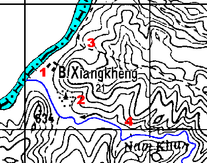
sketch Ban Chiang Khaeng

Ban Chiang Khaeng at river Mekong
Distance between the grid lines: 2 km

view from Ban Chiang Khaeng to the river Mekong

Ban Chiang Khaeng above river Mekong, view downstream

1

view from Ban Chiang Khaeng direct to the river Mekong
view from Ban Chiang Khaeng southward to the mountains

view southwards into the mountains

2

The main monastery
(Wat Luang) of the old
capital Chiang Khaeng

Ban Chiang Khaeng, the stupa of the old monastery

The stupa (dhatu)
of the old monastery

Ban Chiang Khaeng, the old temple, view from South

view from the south in the evening light

Ban Chiang Khaeng, the old temple, view from North

view from the north

Surroundings

3

4

Ban Chiang Khaeng, rice fields at Nam Khun

View from the mountains above Ban Chiang Khaeng at the rice-fields along the Nam Khun, a small tributary of the Mekong

Ban Chiang Khaeng, a pagoda in the djungle

An old stupa northeast of Ban Chiang Khaeng, now overgrown by the jungle

Ban Chiang Khaeng, old documents

Old documents ! The object of the expedition

The scientists studied them, then we took photos

Ban Chiang Khaeng, hospitality 1
Ban Chiang Khaeng, hospitality 2
Ban Chiang Khaeng, hospitality 3
Ban Chiang Khaeng, hospitality 4

Hospitality

Ban Chiang Khaeng, kitchen in the bamboo hut 1
Ban Chiang Khaeng, kitchen in the bamboo hut 2

Caution !  open fire in bamboo huts

Pfeil nach oben
red line

Way back

Ban Chiang Khaeng, Good bye

fare-well at a kitchen

Ban Chiang Khaeng, last picture together

...last picture together

Ban Chiang Khaeng, boarding

... boarding !

Ban Chiang Khaeng, leaving

that was an adventure for all people

Mekong  rapids

the rapids directly in front of the boat
(the red pennants are part of the boat)

Here are the rapids !
The boat collides the rock...
Go on !

the boatman takes a schnapps

Pfeil nach oben

back to prehistory

back to the directory

red line
Valid CSS    W3C-Test